Your cart is currently empty!
Coal-Fielding

Coal-Fielding – 21.7mi / 34.9km
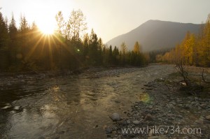
If you are looking for an epic day of solitude, over 5,000 feet of elevation gain, creek and river crossings, and varied terrain conditions on a trail that is not regularly maintained, you will not want to pass up this hike. The trail weaves in and out of the Coal Creek, Muir Creek, Park Creek, and Ole Creek drainages, and varies in scenery from burned forests to dense fir forests. Due to the water crossings and lack of early-season maintenance, this hike is best tackled later in the summer.
The Middle Fork crossing can be extremely dangerous, especially in the spring. Recommended crossing dates are mid August or later, depending upon snow-pack. If in doubt, do not cross.
Trailhead: The trailhead for Coal Creek is on the south side of US Highway 2 between mile markers 169-170. Cross the highway and follow the old dirt road down to the river. For the Fielding side, see Elk Mountain in the 5-10 mile hikes.
Elevation Gain: 5,400ft / 1,620m – Elevation Loss: 3,400ft / 1,020m