Your cart is currently empty!
Cable Mountain

Cable Mountain – 17.7mi / 28.5km
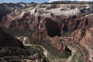
Perched high above the walls of Zion Canyon is the remains of an old, wood frame “draw works” structure. It was used to lower timber down thousands of feet to the canyon floor via a cable, hence, giving this location the name of Cable Mountain. This trail is a nice respite from the crowds in the main Zion Canyon. Access to this amazing vantage overlooking Angels Landing and the Virgin River is from the East Rim Trail.
Starting on the East Rim Trail near the East Entrance of Zion, you travel along a broad trail through slickrock and desert shrubbery. The trail starts off fairly level with some soft, sandy spots along the way. The trail switchbacks at Cave Canyon and begins to climb. You wrap around the point that separates Cave Canyon and Jolley Gulch, with the latter being an impressive canyon. At almost three miles, the trail crosses Jolley Gulch. At the crossing, you stand on a rock slab that looks straight down into a writhing fissure. Years of water eating away at the sandstone have created a dramatic slot canyon to enjoy from a great vantage.
The wide trail continues to climb up onto the plateau. The contrast between the sandstone with desert brush and the ponderosa pine forest is fantastic as you move from valley floor to high perches. Views of the surrounding summits are impressive and constantly changing.
Eventually, the trail traverses the plateau and heads in among stately ponderosa pines. It then drops down towards the intermittent Stave Spring. In this area, a sawmill once stood when the rim was logged and the timber was supplied to the canyon by the “draw works” at Cable Mountain. Follow the signs immediately after the spring to the left, heading west towards Deertrap and Cable Mountains.
The terrain opens up as you climb out of the ponderosa forest. After a little over a mile, the trail forks with Cable Mountain heading off to the right. A little more elevation gain, and the trail drops. The trail ends at the cable structure and the precipitous rock edge of the canyon wall. Be very careful at the edge. Views are nothing short of breathtaking as you look across the valley and far to the north. Angels Landing rises prominently in front of you and the Zion Canyon road follows the Virgin River that snakes thousands of feet below you.
Follow the trail back to your car. Deertrap Mountain can also be reached adding another six and a half miles to the trek. You can also continue on to the Weeping Rock trailhead. For more information on either trip see the Deertrap Mountain and East Rim Summits descriptions.
One last option is to access these trails from the dirt roads on the privately owned Zion Ponderosa Ranch. This route is considerably shorter in distance and less vertical overall. Getting to the trail involves a five mile drive along the North Fork Road east of the Park’s East Entrance, then a left turn onto the signed dirt road to Zion Ponderosa Ranch & Resort. This road is on private property, so please be respectful to the landowners and stay on designated roads and trails. Signage is limited, so refer to the map and follow the more heavily used roads to get to the trailhead. Rainy conditions or snow covered roads may make the road impassible with a car.
Trailhead: From Springdale, take Highway 9 east through the Zion-Mount Carmel Highway Tunnel. Make a left at the turnoff on the north side of the road just before the East Entrance. The trail starts at the gate at the end of the parking lot.
Elevation Gain: 2,800ft / 840m – Elevation Loss: 2,800ft / 840m